 Weather24
Best lightning tracker app? What makes one accurate
In short: the best lightning tracker app for a Florida afternoon storm or a Plains squall line is one that shows measured strikes, not a model’s guess, and tells you when they get close. Three things decide accuracy: where the lightning data comes from, how fast it reaches your phone and whether the app watches your location for you.
A notification when lightning strikes within 6–31 miles of you — in the Weather24 app.
Three kinds of storm data — only one measures lightning
Receivers on the ground pick up the radio signal of each strike; the difference in arrival time at several stations gives its location. In the Weather24 app this comes from the Blitzortung network.
Answers: where is lightning striking now.
Our precipitation layer is the GFS weather model, recalculated several times a day. It shows where heavy rain is expected — it is not a measured radar image and does not show strikes.
Answers: how hard it will rain.
The model works out where the atmosphere has enough energy for thunderstorms in the coming hours. Useful for planning, but it is a probability, not an observation.
Answers: will there be storms later today.
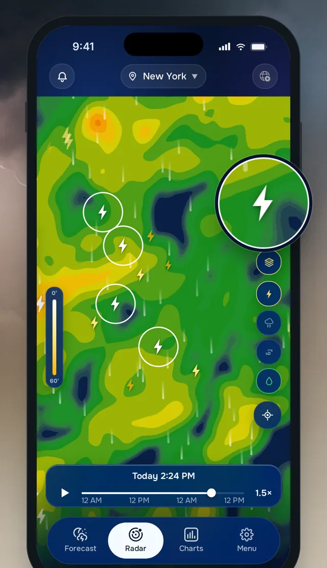
Measured strikes on top of the forecast show where the storm is now and what the model expects next, without switching screens.
Live strikes for any spot: our lightning map.
What makes a lightning tracker accurate
| Criterion | Why it matters | In the Weather24 app |
|---|---|---|
| Source of strikes | Only a detection network records where lightning actually hit | ground-based network (Blitzortung), shown as separate symbols |
| Measured vs. modeled | A model map can look like radar but is a forecast | rain layer from the GFS model, strikes measured by the network |
| Speed | A storm can move several miles in a few minutes | your alert radius is checked for new strikes every 3 minutes |
| Alert distance | Too small and the warning comes late, too big and it never stops | “Lightning nearby” from about 6 to 31 miles (10–50 km), your choice |
| Looking ahead | Plans need the next hours, not only the current moment | map from now to 48 hours ahead |
Lightning on the map, the alert and the 48-hour map are part of Pro.
How lightning tracking works in the Weather24 app
- Turn on the lightning layer. Each recorded strike appears where it was located, on top of the precipitation forecast.
- Look at the newest strikes. New lightning forms on the side the storm is moving toward — that is your direction.
- Set your radius. Pick an alert distance from about 6 to 31 miles; the app checks it every 3 minutes, even when it is closed.
- Check the next hours. Move the timeline to see where the model expects rain and thunderstorms over the next 48 hours.
An accurate tracker also has to reach you
Where you live changes what “close” means. On a Florida summer afternoon, storms often build right overhead, so a small radius can be enough. On the Plains, a squall line covers a lot of ground, and a wider radius buys you time. Live strikes by city: Tampa, Dallas, Denver.
The most precise strike data does nothing if nobody is looking at it. That is why the alert matters as much as the map: it watches your location while you are on the field, the trail or the water. Without the app, the flash-to-bang rule still works — our lightning distance calculator does the math.
Measured strikes plus an alert you can trust — that is what makes a lightning tracker app accurate in practice.
The app gives weather information, not official warnings. Watches and warnings in the US are issued by the National Weather Service.
Track lightning in the Weather24 app
Measured lightning strikes on the map, the model’s precipitation and thunderstorm forecast up to 48 hours ahead, and the “Lightning nearby” alert for the radius you choose — all in Pro.
Frequently asked questions
What is the best lightning tracker app?
What is the most accurate lightning tracker?
Is the rain layer in the Weather24 app a live radar?
Will the app warn me when lightning is close?
How far ahead can I see storms on the map?
See also: Lightning map · Rain radar · Lightning map Tampa
Also worth knowing
UV Index Scale: What Each Level Means and Which Is Safe
The UV index scale from 0 to 11+, what each level means, why Florida and Arizona see extreme values in summer and how the Weather24 app shows the UV index hour by hour.
November 10, 2026 →Lightning Distance Calculator: Count Seconds, Divide by 5
Count the seconds between flash and thunder and divide by 5 to get the distance in miles. A quick table, why it is only an estimate and how the Weather24 app shows the nearest strike.
November 8, 2026 →Normal Barometric Pressure: What’s Normal in inHg and hPa
Normal barometric pressure is 29.92 inHg at sea level, but your reading depends on altitude. What range is normal, why Denver reads lower and how the Weather24 app shows today’s pressure.
November 7, 2026 →